
Champoluc
Across the mountains
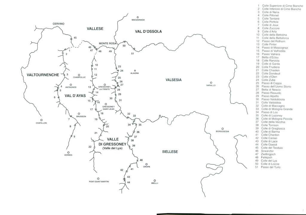
The Val d’Ayas, together with the neighbouring Lys and Sesia valleys, the Biella valleys to the east and the Valtournenche to the west, are lands of ancient trade routes and regions where different cultures have intermingled; a group of valleys where the longitudinal routes along the valley floors—which descend southwards from the main ridge of the Alps—were naturally of great importance, but the transverse routes leading from valley to valley across numerous side passes were equally significant [1].
Indeed, various historical sources indicate that, at least until the early 20th century, the inhabitants of these territories perceived their own spatial context as encompassing this cross-Alpine dimension, which coexisted alongside—and on an equal footing with—the trans-Alpine dimension and that associated with the north-south orientation of the valley.
The Alpine historian W. A. B. Coolidge states that: “It is entirely wrong to imagine that a mountain range always separates, in an almost absolute way, the inhabitants living on one side from those living on the opposite slope (whether it is the main Alpine watershed or one of its secondary ridges). This image may seem realistic to travellers arriving from the plains who are in a hurry. History teaches us, rather, that mountain passes bring closer the regions situated on their opposite slopes to such a degree that these regions are often bound to one another by ties far stronger than those they have with other areas with which they might appear, in fact, more closely integrated thanks to greater ease of communication.” [2]
A few decades earlier, in 1869, similar sentiments had been passionately expressed by Amè Gorret, a native of the Aosta Valley, in his famous “Discours de Varallo”: “The large and impressive gathering before which I have the honour of speaking tells me quite clearly that these ramparts no longer separate us; it is precisely these mountains, these passes, these obstacles that bring us together here.” [3]
In his classification of Alpine passes, Coolidge identifies eight major historical passes in the Western Alps, among them the Little and Great St Bernard, and also describes the Col du Théodule from a historical perspective. For the valleys we are concerned with, these three passes represent the principal transalpine structure, and many of the lateral cols found in this territory, while remaining on a transverse scale, also stand in a “functional” relationship with the transalpine connections. Foremost among these is the route that crosses in sequence the Colle Valdobbia, the Colle Ranzola, and the Col de Joux in the direction of the two St Bernard passes — or vice versa — and the route that climbs via the Col d’Olen, the Colle della Bettaforca, and the Colle delle Cime Bianche to reach the Theodule Pass. Alongside these itineraries there exists a dense network of routes that served the various agropastoral, commercial, migratory, religious, military, and artistic purposes of intra-valley significance, finding in the lateral — or minor — cols their structural backbone. All of this, however, was set within a closed socio-economic environment in which the self-consumption of agricultural produce and the self-production of tools and implements prevailed.
Returning once more to Coolidge, we read: “The Mountain was created by Nature, but the Pass was created by Man. In other words, Mountains are natural phenomena, whereas passes are not ‘Passes’ until man has crossed them, even if, clearly, the depressions in the ridges may have been marked by Nature… And there can be no doubt that Passes were crossed before Summits were climbed. Indeed, while the inhabitants of the Alps crossed the passes for practical reasons, it was only rarely that they sought to ascend the peaks of their mountains in times predating the arrival of travellers. The reference to a [glacial] pass on a map or the indication of a route crossing it requires that someone has actually traversed it. On the contrary, assigning a name to a summit, whether in speech or in writing it on a map, does not in any way imply that it has ever been climbed, since names were given to peaks by observing them from places situated far below, while names were conferred on passes only after they had been crossed.” [4]
If we give credence to the author, as we must, the large number of names assigned to gaps, clefts, and depressions in the ridges that we find in our area of interest bears witness to how numerous the intra-valley connections must have been, how many passes were actually crossed and crossable, and how dense a web of interlocking routes could have linked one slope to the other, facilitating the movement of people and goods between adjacent valleys.
From a purely numerical standpoint, in the area under consideration, in addition to five glacial passes crossing the ridge of the main Alpine chain, there are no fewer than forty-six passes, of which nine lie between the Val d’Ayas and the Valtournenche and the central Aosta Valley, thirteen between the Val d’Ayas and the Valle del Lys, and between the latter and the Valsesia and the Biellese respectively nine and twelve, plus two historic passes between the Valsesia and the Val d’Ossola.
Beyond the mere geographical evidence, numerous documents over the last three centuries have shed light on — and enriched with information beyond the topographical — the side valleys and passes linking the Val d’Ayas, the Valle del Lys, and the Valsesia with their neighbouring valleys: from the reports drawn up by geographers, officers, and Savoyard officials in the 17th and 18th centuries, to the studies of scientists from beyond the Alps who explored the Alps in the second half of the 18th century, to the notes of English travellers who traversed the Aosta Valley in the 19th century, to the numerous tourist guides published in several countries.
Yet the written sources available to us indicate at most the directions followed by those flows, but tell us nothing of their scale; and these same sources are relatively recent when placed within a long-term historical perspective.
The first systematic treatment of the passes giving access to or egress from the Val d’Ayas had military motivations. In the 17th and 18th centuries, the Duchy of Aosta relied on the line of Bard as one of its key strongholds for the northern defence of the Piedmontese and Valdostan territories. For an army advancing from France, bypassing the fortress by descending through the Valle del Lys after crossing the Val d’Ayas could have been a viable option. For those arriving from the east — such as the Spanish during the War of the Mantuan Succession — it meant entering the Duchy of Aosta through the passes leading from the Valsesia into the Valle del Lys and from there into the Val d’Ayas. In the reports of Romagnan, Rombò, and other Savoyard officials, we find a detailed list of the numerous passes between the Val d’Ayas and the Valle del Lys, their passability — whether limited to persons or accessible also to pack animals — the existing fortifications on each and those to be rebuilt, and the precise number of soldiers required to garrison them. The Bettaforca and Ranzola passes required larger garrisons owing to their accessibility to pack animals as well.
After the military came science. First the geologists and topographers in the service of the King, then scientists from beyond the Alps began to make their appearance. De Saussure, Von Welden, and Forbes would all leave traces of their transverse crossing of the Val d’Ayas in their writings. The first, from the Valsesian village of Riva, crossed the Colle Valdobbia, the Bettaforca, descended to St. Jacques, and from there made his way to Breuil via the Cime Bianche, before crossing the Theodule. Von Welden describes in great detail the numerous routes linking the upper Valtournenche to the adjacent valleys of the Évançon and the Lys. James David Forbes, in the mid-19th century, crossed from Chamois over the Colle Portola, descended into the Val d’Ayas, noted with interest the landslide at Pracharbon, and continued on to the Colle Ranzola and then the Col d’Olen.
In the wake of the first scientists came travellers and mountaineers, at first predominantly British. John Ball descended into the Val d’Ayas from Zermatt via the Colle della Porta Nera; the Reverend King, with his wife Emma, climbed the Val d’Ayas from the Col de Joux, stopped at Soussun, and crossed the Bettaforca; subsequently, the Reverend ascended the Valle di Challant as far as Brusson, from where he crossed the Colle Ranzola in the direction of Gressoney. Many others followed, among them Mrs Cole and Thomas Malkin. The growing publication of travel books and tourist guides, both in England and on the European continent, increased the number of those who discovered and traversed the valleys lying south of Monte Rosa. The lateral passes saw a new type of visitor, but over time their numbers gradually dwindled, and many passes eventually fell into oblivion from the moment a name had first been given to them.
The prestige of the side peaks finds a firm point of reference in the figure of Abbé Gorret, who, in 1870, having decided to attend the extraordinary meeting of the Italian Alpine Club in Domodossola, had no doubt that “The journey was to take us across the mountains.”
[1] Note. Part of this work is taken from: L.Capra, G.Saglio, Attraverso i monti. Colli e collegamenti intra-alpini a sud del Monte Rosa, Valle d’Ayas e Valle di Gressoney, Valsesia e Valli Biellesi occidentali, “Quaderni di Cultura Alpina”, Priuli & Verlucca editori, Ivrea, 2001.
[2] W.A.B. Coolidge, Le Alpi nella natura e nella storia, Zeisciu Centro Studi, Magenta, 2019.
[3] A. Gorret, Autobiographie et ecrits divers, Administration Comunal de Valtournenche, Valtournenche, 1987, p. 113.
[4] W.A.B. Coolidge, ibid.