Les Fusines Li Fejeune – 1.700 m Blanchard Biantchart – 1.724 m Rovinal Rovénal – 1.709 m Praz-Sec Pra-Sec – 1.700 m Les Péyoz Li Péyo – 1.725 m Les Droles Li Drole – 1.757 m Bernosin Bernozìn – 1.750 m
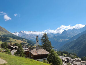
The small hamlet of Corbet (Corbet in the local dialect), like the neighboring villages of Meytéres, Le Trochey, and Le Cornu, is situated entirely on the orographic left side of the valley floor. Together, they seem to nestle into the terrain, following the contours of the land to achieve the best possible orientation toward the sun.
These place names first appear in historical documents after the 17th century, since in earlier times there were only a few scattered houses on the narrow strips of flat land, and the area was considered merely a “canton” known as “Ultra Aquam,” meaning “beyond the bank of the Evançon stream.”
In 1257, along with the villages of Pilaz and Magnéchoulaz, the communities of Ultra Aquam received as a fief from the local lords a vast forest stretching from Corbet to Pilaz on the left bank of the Evançon, the so-called ‘bois noirs’. The enfeoffment was then confirmed in 1402.
This marked the first step toward a reorganization of the territory with the emergence of isolated farmsteads, the nuclei of future villages, traces of which remain today primarily in the rascards (some of which still bear the construction date engraved on their beams) and in the communal ovens.
Corbet appears to be the most recent village, as records from a trial held in 1531 indicate that only animal stables existed there at that time. The main historical features of this small hamlet are an ancient rascard on a stone foundation, the tall chimney of the oven, and the imposing stone building (Casa Champrétavy) with a devotional fresco from 1951 depicting Saint Anthony of Padua.
Map of Corbet
The local area
Once much of the territory of Ayas was cultivated and in the fields rye, wheat, barley and potatoes were grown. The men, skilled masons, had cleared and consolidated the stony mountain slopes, creating proper arable fields arranged on several levels, often supported by dry-stone walls. The terracing, still clearly visible today, constitutes an important historical and cultural heritage, bearing witness to the difficulties and hardships that the inhabitants had to endure in order to live in the high mountains. Another predominant activity was livestock farming (sheep and cattle).